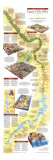
* Lesson plan idea - have your students research for updated information on the archeology of the Nile River Valley • maps
“Concerning Egypt I will now speak at length, because nowhere are there so many marvelous things, nor in the whole world beside are there to be seen so many works of unspeakable greatness.” ~ Herodotus
PYRAMIDS - Egypt entombed its first kings in mastabas, the low, chambered rectangles of mud brick that were the first stage in the evolution of pyramids. The architect, Imhotep, in building the burial place of the Pharaoh Djoser at Saqqara, began with a square mastaba which he ingeniously developed into a stepped pyramidal structure. Smoothing the angle of ascent to a pointed summit came obviously to the tomb builders that followed. The art of the pyramid and its complex of valley chapel, causeway, and funerary temple culminated at Giza and survived until the XIIth Dynasty. More than 70 stone or brick pyramids of sizes commensurate to the might of their builders are scattered throughout Egypt and Nubia.
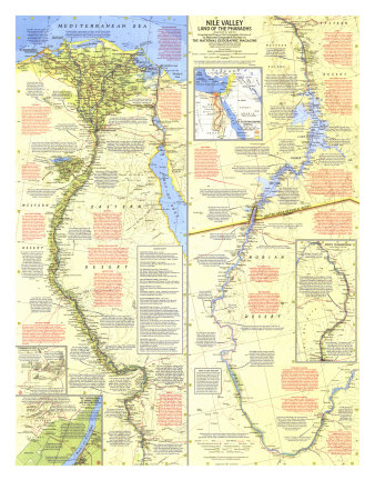
THE EGYPTIAN NILE - Neolithic hunters first settled the long green oasis that would become Egypt and accepted the Nile's double-edged gift – the flood. This yearly inundation of water and mud covers the thirsty shores from June to October and renews the land with a fresh layer of rich silt – but the variation in the flood's annual volume spells feast or famine for all Egypt. Attempts to predict, record, or control this capricious generosity led to the development of history's tools: a simple astronomy, an accurate calendar, a written language, an accounting system, and basic construction devices. The Nile's greatest gift was Egyptian civilization.
THE HYKSOS - During the 17th century B.C., the Delta was gradually infiltrated by Asiatic nomads whose numbers and strength grew in proportion to Egypt's internal weakness. The creeping conquest of these Hyksos, or “princes of foreign lands,” eventually included all Egypt; two subsequent Hyksos dynasties governed the land of the Pharaohs from a capital in the northeastern Delta, perhaps the site of Tanis. The foreign rulers were finally driven from Egypt by the Theban princes of the XVIIth Dynasty and by Ahmose, founder of the XVIIIth Dynasty.
THE FAIYUM - Discovered and inhabited by the Nile Valley's earliest hunters, the lush and fertile area of the Faiyum (editor note - an oasis) became a favored resort of the Pharaohs of dynastic Egypt, who reclaimed much land here by regulating the inflow of water from the Nile.
EGYPT AND THE BIBLE - As a southwest neighbor, Egypt had, from earliest times, exerted its influence on the lands of the Bible. Correlation between people and events in the two areas is conjectural, but some scholars agree that Joseph was honored by one of the Hyksos kings. The Pharaoh of the Oppression was probably Sethos I, whose son, Ramesses II, would be Pharaoh of the Exodus. An Egypyian victory over the Israelites in Palestine is mentioned on a stele in the Temple of Merneptah in Western Thebes.
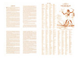
RELIGION - Seldom have gods been so numerous or their influence so strong as in the Nile Valley of the Pharaohs. The Egyptian accorded his highest homage to the all-covering sky, to Amon-Re the sun, and to the beneficent Nile, but lesser gods were revered in every natural form. Countless plant and animal deities were supplemented in mythology by man-gods, chief among whom stood Osiris. The myth of this murdered Nile gods resurrection through the love of his sister-wife, Isis, mirrors the prime tenet of Egyptian religion – fervid belief in immortality. As Osiris rose from the dead, so should man – and the Egyptian accordingly spent, his days in preparation for an afterlife.
PAINTING AND SCULPTURE - Egypt's anonymous artists adorned its tombs and temples with a multitude of gods and Pharaohs acting their traditional roles in myth and history. The tombs held representations of everyday life as well: laborers at their tasks, farmers in their fields, retainers serving their masters. These, and replicas of all that man needed in life, were placed there for the use of the immortal soul in the afterlife. Inspired by religion, Egypt's art has indeed perpetuated its civiliation; even time does not lessen the forceful confidence of the sculpture, the linear eloquenced of the bas-relief, or the vivacity of the painting.
ARCHITECTURE - Egyptian architecture seems a royal and holy art, for only the tombs and temples were of lasting stone. The wood and brick construction that sufficed for men and kings during their life on earth crumbled long ago, isolating the mighty monuments that still cast shadows on the sands of Egypt. Pillars and columns, already in use when the first pyramids were built, became an increasingly common feature in the courts and porticos of the tombs and temples of the Middle Kingdom. These durable structures are as varied as they are profuse: some are cut from living cliffs, some free-standing on the shores, some delicate in size and decoration, others awesome in their immensity. In vast complexes at Egypt's ancient capitals or scattered in lands once subject to the Pharaohs, they are the highest development of Egypt's supreme art.
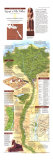
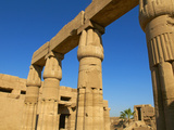
THEBES - A broad plain, mountain-rimmed and cut by the Nile, holds this ancient capital whose several parts were, together, called Thebes by the Greeks. Luxor, on the east bank, is now a modern town, built around the 3,400-year-old temple of Amenophis III. Karnak, or Thebes proper, crowded with the mounumental architecture of Egypt's Age of Empire, lies slightly north. Its 60-acre complex of temples, chapels, giant stone Pharaohs, and commemorative obelisks is crowned by the largest columnar structure ever raised, the Temple of Amun, built by generations of Pharaohs over a span of 2,000 years. Across the river lies the Theban necropolis, the City of the Dead, and the Valley of the Kings.
ABU SIMBEL - Nubia's noblest monuments were carved into the sandstone cliffs at Abu Simbel in the 13th century B.C. Fronted by towering colossi, the temples of Ramesses II and his beloved queen Nefertari extend deep into the rock, Their chambers adorned by columns carved in place, their walls rich with reliefs and inscriptions. threatened now by the waters that will rise behind the High Dam, the temples are being cut into 30-ton blocks which will be lifted 200 feet and reconstructed in a duplicate setting safely above the level of the reservoir. The project, financed by UNESCO's international fund drive, will cost 36 million dollars.
THE NUBIAN NILE - The Nile describes a great awkward S-curve in the baking desert north of Khartoum, its hurried lfow through Nubia accelerated six times by the rapids of the granite-ribbed Cataracts of the Nile. Above the 2nd Cataract, the river careens through the rocky Batn el Hagar, the 100-mile Belly of Stone, and rushes on to Aswan, where its force is to be checked by the High Dam.
NUBIA - Nubia's fluctuating boundaries are defined only by history, but the region retianed an identity because its people speak the language called Nubian. They have lived in the slender river valley from the 1st Cataract at Aswan to beyond the 3rd Cataract in Sudan for more than 5,000 years, successively dominated by alien empires and faiths. Egypt's Pharaohs ruled the area for a thousand years, making a battleground of its frontiers and a treasury of the fabled Nubian gold mines. For the next thousand years, Nubia had as many masters as did fallen Egypt, but still the mark of this land is that of the Pharaohs whose temples stand today along the Nubian Nile. The gods of Egypt fell long ago to the haloed saints of Coptic Christianity, who, in turn, lost Nubia as the minarets of Islam rose beside the river.
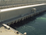
THE ASWAN HIGH DAM - Sad el Aali, the Aswan High Dam, under construction by the United Arab Republic with Russian assistance, will harness the Nile's annual and erratic June-to-October flood. The precious water and its cargo of silt from the uplands of Ethiopia will be caught behind the two-mile, billion-dollar dam in a reservoir that will extend past the Dal Cataract in Sudan and provide irrigation of 2 million now-barren acres. The dam's hydroelectric plant will further bless the over-populous Nile Valley with more abundant and less expensive electric power. The project has one inherent problem: the 300 miles of river valley to be filled by Lake Nasser, the reservoir, is populated by some 100,000 Egyptian and Sudanese Nubians who are leaving their historic homeland for relocation villages north and south of the lake.
ARCHOLOGY AND THE HIGH DAM - The slender length of Egyptian and Sudanese Nubia, so soon to vanish under the dammed-up Nile, is a museum of the past, crowded with the shards of old civilizations. The tools and trinkets of Neolitihic man lie beneath the traces of the Nubian's earliest settlements. The inscriptions, temples, and fortresses of conquering Egyptian Pharaohs share the river's shores with the cities of Nubia's native kings and the temples of Graeco-Roman rule. Coptic churches of the Christina Era stand with reminders of the Turkish occuption and mosques of the Arab conquests. More thn 40 archeological teams from all over the world work feverishly in Nubia to save what they can of this doomed chapter in man's history. They are rescuing more than 20 of Nubia's most impressive monuments, the rest can be preserved only through intensive study and documentation, now in hurried progress under the auspices of UNESCO and a special agency of the U.A.R. Ministry of Culture.
SUDAN - Moslem raids from the north reduced the Christian kingdoms of Nubia to anarchy. Subsequent conquest by the Fung, the powerful nation of Arabized Negroes to the southeast, led to Nubia's convesion to Islam by the 16th century. In the early 1820s Mohammed Ali, Pasha of Egypt, invaded and conquered the Sudan, in decline after the wane of the Fung. Lost by Egypt to fanatic Moslems under Mohammed Ahmed, the self-proclaimed Mahdi, or guide, of Islam, the land was soon reconquered by Lord Kitchener. An agreement, January 19,1899, established joint rule by Great Britain and Egypt throughout the Sudan and set its northern boundary at the 22nd parallel. This land, a meeting place of Arabic and Negro Africa, became a sovereign independent state on January 1, 1956.
THE PTOLEMIES - The last royal dynasty of the Nile mirrored all the dynasties before it; the kings feuded among themselves, warred with outsiders, and, when time permitted, added to or restored the architectural grandeur of Egypt. These rulers were neither Pharaohs nor Egyptians, however, but Macedonians, descendents of Alexander's trusted general Ptolemy I, who was appointed to rule Egypt after the conqueror's death in 323 B.C. The old empire of the Nile died with Cleopatra, last of the Ptolemies, in 30 B.C. when Egypt became a Roman province.
SOURCES OF THE NILE - The origin of the world's longest river was a legend-clouded mystery until the Burton-Speke expeditions found the Lake Victoria source of the White Nile in the mid-1800s. This longest of the Nile's two branches falls from the East African mountains, struggles through the 50,000-acre papyrus-choked swamp called the Sudd, and then, weakened, continues northward. The second branch, the turbulent Blue Nile, races down from Lake Tana in the Eithiopian highlands, swollen with mountain rains and darkened by accumulated silt, to provide the major force and volume of the union. The two end their separate journeys at Khartoum, whre they converge to form the mighty Nile of Nubia and Egypt.
THE XXVTH DYNASTY - During a decline of Egyptian might in the eighth century B.C., a Nubian ruler, Kashta, established the independent kingdom of Kush in southern Nubia. His successors extended their power over all Egypt before they were pushed south again by the Assyrians around 660 B.C. The temples, monuments, and tombs erected by the Kushite rulers were but crude imitations of those in the Egypt thy once conquered.
PUNT - Somewhere to the south of Egypt, possibly as far as the area of Somaliland, lay the land of gold and incense, fabled Punt. The kings of Egypt sent trade missions there as early as the Vth Dynasty; the Palermo Stone describes the expedition of the Pharaoh Sahu-Re. Reliefs at Deir el Bahri, Theban temple of the female Pharaoh Hatshepsut vividly portray her commercial ministers in the southern land treating with its king and his grossly fat wife for the riches desired by the Egyptian queen.