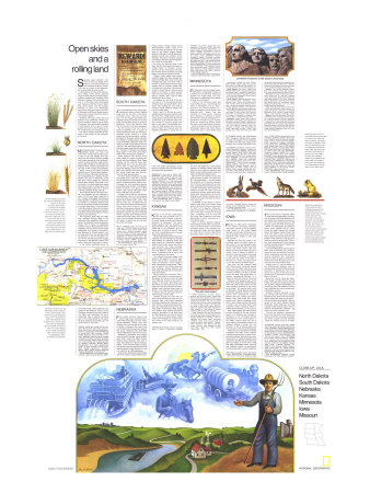
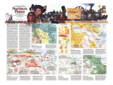
The 1974 North Central Plains: Open Skies and Rolling Land map features:
• Inset of Lake Sakakawea and Garrison Dam in South Dakota
• Landmark Treasures of the Nation's Heartland highlighted
• An introduction to the region
• A travel article on each state
• Colorful illustrations
* Lesson plan idea - have your students update the information and latest statistics concerning the Plains of the United States; discuss, contrast and compare the political, economic (employment), and environmental (climate change) situations the Midwest region is dealing with currently. • maps
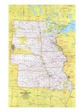
North Central States map text -
Open skies and a rolling land - Surprises await travelers who think of the seven states (the Dakotas, Nebraska, Kansas, Minnesota, Iowa and Missouri) at the nation's north-central heart as a flat, monotonous apron of land. True, here is a realm of vast expanses. But a remarkable diversity exists.
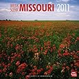
Lakes pop out of Iowa's corn and Kansas's wheat. North woods quietude reigns over Minnesota's forested ridges, bubbling streams and woodland color Missouri's Ozarks. The storied days still ring of a Wild West that immortalized such names a Wild Bill Hickok, Wyatt Earp, Jesse James, and the Younger brothers. In short, from Mississippi River bluffs edging the east to the hills of Nebraska's and South Dakota's west, these states of plain and prairie boast a rich vacation appeal.
Breaking through the tough prairie sod and enduring the sometimes violently capricious weather shaped a hardy breed of pioneers. Their descendants, steeped in self-reliance and in awe of forces greater than man, come through as often conservative and strongly religious – but with a friendly openness as welcome to the traveler as the immensity of the land.
Pioneers breaking the prairie met a sod so matted with roots it had to rot two years to become easily tillable. But where big bluestem – tall enough to screen a cow from a man on a horse – and other tall grasses grew, there man's high grass, corn, could thrive. And on drier soils where shorter types like buffalo grass and little bluestem spread, there man could grow his shorter grass, wheat. Thus were the plain and prairie tamed. *see Wes Jackson at The Land Institute
The 178-mile-long Lake Sakakawea, named for the guide who lead Meriwether Lewis and William Clark on their westward trek, was created by a dam across the Missouri River.
The wire that tamed - Called “treacherous, truculent, temperamental, and just plain mean,” barbed wire did as much as any single invention to end chaos and bring demarcation to the limitless horizons of th range. The first U.S. patent adding barbs to the wire that had been used for years to keep animals and tespassers out came in 1867; within a short time hundreds of variations had been produced to keep livestock in. That change of concept revolutionized farming and ranching. ...
Landmark treasures of the nation's heartland ... Vacationists crossing the North Central States seldom equate plains and prairies with units of our National Park system. Yet a score are there, and worth stopping for.
NORTH DAKOTA - North Dakota doesn't trumpet its considerable assets; you must hunt them down: colorful late-summer country fairs in the rich eastern farm belt, more than 60 national wildlife refuges that protect everything from white pelicans to prairie chickens, huge recreational lakes create by the dammed-up Missouri River, cowboy and Indian lore still alive in the roundup and powwow.
About a third of the state's 618,000 residents are of Scanadinavian descent. Ethnic touches of Norway and Germany were bequeathed by a parade of early settlers. The town of Mountain in the Red River Valley stages an Icelandic festival each August. That valley, once the bottom of a glacial-age lake, waves with seas of grain on fertile farms. The state traditionally ranks first or second in barley, flaxseed, wheat, and rye.
North Dakota shares 310 miles of border with Canada, and the crossing is easy. U.S. 281 and State 3 take you to the formally landscape Interational Peace Garden, a 2,300-acre monument to friendly U.S.-Canada relations and the site of summer concerts by students of a music camp there. The surrounding Turtle Mountains bristle with the state's only appreciable timberland and shelter a number of small lakes ideal for fishing, boating, and swimming.
Two highways, State 1804 and 1806, bear numbers echoing dates of the Lewis & Clark expedition. When completed, the roads will trace the explorers' routes with a series of interpretive markers. It was in North Dakota that the expedition met the Indian woman guide Sakakawea, who stands in bronze beside Bismarck's 19-story capitol; from an observation floor you can see across the Missouri to old Fort Abraham Lincoln and to reconstructed earth lodges like those of the Mandan Indians with whom Lewis and Clark spent a winter.
In the state's southwest corner lie the multicolored buttes, tablelands, and gorges of the Badlands. There a young Theodore Roosevelt punched cattle in the 1880s and celebrated his joy of wilderness. Now a national memorial park in his name preserves his cabin, hards of longhorns and buffalo, and 110 square miles of wild land.
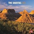
SOUTH DAKOTA - Just as prospectors did a century ago, adventurers drawn to South Dakota today head for the hills in the state's southwest corner. Then the lure was gold; now the magnet lode yields such nuggets as Mount Rushmore and Jewel Cave, the Wild West towns of Lead and Deadwood, Wind Cave National Park with its remnant of pristine grassland.
But the curious visitor can find attractions elsewhere, too. A cluster of natural freshwater lakes dots the state's northeast corner, making it a prime skating and ice-fishing region in winter. Northeast of Aberdeen stands restored Fort Sisseton, recalling Indian-war days of the the mid-1800's. Mitchell's huge, turreted Corn Palace sports exterior murals “painted” with varicolored ears of corn; it houses a week-long festival in September. Touches of Germany and Scandinavia linger in the fertile James River Valley, where immigrants pioneered.
South Dakota's own version of the Great Lakes is a chain of bulging reservoirs along the Missouri River. Dams backing up the artificial lakes offer powerhouse tours. You can also boat, picnic, swim, or seek fishing prizes–15-pound walleyes, 35-pound northern pike, even strange 100-pound paddlefish who lower jaws drop like elevators to open gaping maws.
A Plains Indian homeland, the state has 32,000 Sioux; most live on the adjoining Rosebud and Pine Ridge Reservations. Rosebud Indians hold an end-of-August fair with ceremonial dances and buffalow-steak dinners. Pine Ridge's Indians conduct a sun dance in early August near storied Wounded Knee, site of 1890 and 1973 conflicts.
At Cactus Flat or Wall you can dip into the Badlands, a terrain of wind-blasted rock and water-cut canyon that Indian fighter Gen. Alfred Sully called “hell with the fires out.” At Rapid City you can strike out for the Black Hills attractions: Custer State Park protects a buffalo herd that a hired jeep and guide will take you to see; Deadwood's Mount Moriah Cemetery hold the graves of Wild Bill Hickok, Calamity Jane, Preacher Smith; Lead (pronounced Leed) lives up to its name–the Homestake Gold Mine paces the nation in output and you can tour its surface workings.
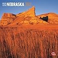
NEBRASKA - From prairie schooner days to the station wagon age, westering Americans have contiually put down tracks across Nebraska. Though some have stopped only long enough to fix a wagon wheel or change a tire, there is reason or the traveler to pause and explore this broad, sweeping land that Willa Cather celebrated in many of her novels.
Nebraska's population and industry are anchored in the east, where the Missouri River marks the state's border, cutting along farmland once part of what was called the “Great American Desert.” Corn here and cattle on grassland farther west now give the lie to that label bestowed by Maj. Stephen H. Long in a report on an 1820 exploration.
Grain and livestock also make Omaha one of the nation's major livestock marketing centers. Though trends toward decentralization lessen loads in its one-brimming stockyards, the city still lures as the state's largest. Nearby Bellevue, Nebraska's oldest settlement displays aircraft and missiles at the Strategic Aerospace Museum edging the Strategic Air Command's headquarters, Offutt Air Force Base.
At Lincoln the 400-foot tower of the State Capitol dominates the skyline; a notable statue of Abraham Lincoln stands close by. Visitors also can trace the life and career of William Jennings Bryan in the prairie Populist's home.
Trapper, trader, wagon train pioneer, overland stage, and pony express followed the Plate River west, and today Interstate 80 does the same. With a handfull of stops reached from this well-tended road–in summer guides offer information at rest area–the drive becomes a history lesson. Among noted places: Fort Kearny of Indian warfare days, the pony express station at Gothenburg, Buffalo Bill's Scout's Rest Ranch near North Platte.
At Ogallala you can pick up the history trail on U.S. 26, passing towering Chimney Rock and Scotts Bluff–landmarks that showed the way west to pioneers whose rumbling wagons left ruts still visible today.
State 2 and U.S. 20 take you northwest across less-traveled routes through the Sand Hills, 19,000 square miles of rolling, grass-covered dunes. Here small ranches put up at moderate rates a limited number of working guests who want to get close to the everyday business of a cattle spread. Here, too, hundreds of lakes form stop over spots for migrating waterfowl in spring and autumn. The state's northwestern corner beckons campers with evergreen ridges and weird rock formations.
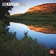
KANSAS - is not the flat, baked tableland that many conceive. Nor is it particularly corny in August, or any other month; wheat, oil wells, and livstock dominate its landscape. The terrain slopes upward from an elevation of about 700 feet in the southeast to some 4,000 feet in the northwest, and the visitor who is willing to look for them will find a surprising array of recreational and historical sites.
Most of the state's excellent eaat-west highways fan from Kansas City, Kansas, appropriately an industrial center that grew where the industrious Wyandot Indians built a town; stores and offices now surround the tribal cemetery. With its larger namesake flanking it beside the Missouri River, Kansas City forms a metropolis that is one of the most sprawling in the nation.
The majority of Kansas's bigger cities cluster in the eastern third of the state. There three of them – Lawrence, Manhattan, and Emporia – form a triangle of leafy, progressive college towns. There, too, lie many of the artificial lakes that offer camping, fishing, boating, and other water activities within an excellent state park system. Worth exploring are the Flint Hills, a gently tilted series of outcrops that ripple grassy and scenic across the state from Marshall County in the north to Cowley in the south. Wild flowers dot the slopes from spring through autumn. Eight-foot-high big bluestem and other grasses once nurtured great herds of buffalo; now cattle thrive on them, and in autumn you can see stock driven to market along country roads.
Spotted through the Flint Hills are such tree-lined towns as Alma and Cottonwood Falls, their sturdy limestone buildings reflecting the character of the land. Towns in central and western Kansas once resounded to the gunfire and hoof clatter of trail-driving days. Dodge City, Abilene, Hays, Wichita, and others preserve reminders of that Wyatt Earp and Bat Masterson era. And at Quinter you can go by covered wagon, stagecoach, and horseback on a wagon train trip of two to four days along an old pioneer trail.
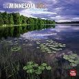
MINNESOTA - Far removed from the nearest ocean, Minnesota nonetheless thrives on a watery love and live-style. Retreating glaciers let 15,000 lakes; from one, Lake Itasca, the Mississippi River begins its long flow southward.
Grown to an imposing stream 500 miles farther along, it cuts through the cities of Minneapolis and St. Paul – economic and cultural bastions of a state that, despite its north woods “get-away-from-it-all” appeal, has vast stretches of rolling prairie. Towering grain elevators, a hallmark of prairie architecture testify to Minnesota's importance in the nation's grain markets; fertile soil dropped by glalciers makes the state a major agricultural producer.
South and east if the Twin Cities that Mississippi cleaves high bluffs. Scenic routes here and in other states along the river are tagged by a pilot's wheel emblem on highway markers. Near Red Wing the river widens to become Lake Pepin, where vacationists fish, boat, an water-ski between distant banks.
But most of the patches of blue that gave the state its name–an Indian term for “sky-tinted water” – lie in the central and northern tiers. There the long, eerie cry of the loon punctuates the summer dusk. Lakeside resorts range from rustic to plush. Increasingly they extend their seasons through the area's hard but invigorating winters; guests busy themselved with snowmobiling, skin touring, iceboating, ice fishing in heated huts, or trekking through snow-laden woods of birch and pine.
A gateway to the region is Duluth, where cargo ships from distant lands glide in and out of the port formed with its sister city of Superior, Wisconsin. Visitors can watch a lift bridge soar 120 feet in less than a minute to let ships pass. A highway–U.S. 61–from the port skirts Lake Superior to the Canadian border, scenic, piney sort of inland Maine coast.
North of Duluth, Superior National Forest blends crystal lakes, rocky shorelines, and deep woods in a picturesque northland retreat. At Ely outfitters supply equipment, maps, and even guides for trips into the forest's labyrinthine Boundary Waters Canoe Area. And on the Canadian border, near International Falls, Voyageurs National Park evokes the days of doughty French-Canadian fur traders who left every rapids, every portage, every stream with tales to tell.
IOWA - Perhaps no state better symbolizes the nations cornucopia heartland than Iowa. A fourth of all the highest-grade topsoil in the United States spreads over the state; 94 percent of its area is devoted to agriculture, and only California ranks ahead in total cash farm income.
Wooded hills and river bluffs in the northeast break the state's highly visible carpet of corn and soybeans; lakes dot the northwest with sites for summer resorts and winter sports. But even where the deep-green fields stretch to infinity, there is beauty to behold. In spring the upturned acres roll like seas of black velvet. Winterset, in Madison County near the center of the state, is the heart of a lovely rural region noted for its 19th-century covered bridges.
Iowa farm life has changed vastly since West Branch produced Herbert Hoover and Van Meter sent Bob Feller to the Big Leagues. You can sample that life with a vacation on a farm; a number around the state offer guests sheer relaxation, recreational facilities, or a chance to help with chores if they like.
Highways and byways known as the Great River Road follow the Mississippi where the Iowa border marks one of the most dramatic stretches of the river's entire length. On soaring bluffs north of Marquette, Effigy Mounds National Monument preserves traces of Indian culture with centuries-old mounds shaped like birds, snakes, and bears. Nearby Pikes Peak State Park draws tourists with colorful sandstone cliffs, falls, a cave, Indian mounds. Becoming a country lane, the Great River Road meanders toward Dubuque, where a paddle-wheel steamer runs excursions.
Near Cedar Rapids the seven Amana colonies function as the last surviving branch of a Pietistic sect founded in Germany in 1714. The Amana Society aboandoned its strict communalism in the 1930s. Visitors today can tour a shop making handcrafted furniture, an appliance factory, a woolen mill, and wineries, or eat at German-style inns and take part in the annual Oktoberfest.
Factories sprout alongside cornfields throughout the state; Iowa's industry outranks its agriculture in value of output and produces items from tiny electronic parts to mammoth earthmoving machinery. Des Moines, the state's biggest city, began as a river fort in 1843 and today dominates Iowa's industrial and financial picture. In mid-August the city erupts with a colorful state fair.
MISSOURI - Two of the nation's mightiest waterways define the geography, industry, and life-styles of the Show Me State. And two mighty cities linked by the river system form front and back doors for this singular land at the heart of the nation.
Where the Mississippi and Missouri Rivers come together sits St. Louis. Across the state, Kansas City sprawls where the Missouri bends toward the north. The latter, once a river landing that pioneers braving the Santa Fe and Oregon Trails used as a jump-off point, drew its growth by facing west. The former long oriented itself more towards the East and New Orleans. Together the two dominate the state.
Life on the Mississippi has changed in Mark Twain's Hannibal, but a museum, boyhood home, and various Tom-Huck-Becky memorabilia recall the mid-19th-century steamboat era. Southward, State 79 clings to green riverbanks; at Clarksville a chair lift takes you to Lookout Point atop one towering bluff.
Soaring over St. Louis's waterfront, the 630-foot-high Gateway Arch of stainless steel commemorates westward expansion. A spectacular view of this proud old city and its environs can be gained from an observation room at the apex of the arch.
Downriver from St. Louis, Ste. Genevieve recalls its 1730s French colonial origins with restored homes and a lively Jour de Fete in August. And Sikeston, on the alluvial plain that is Missouri's bootheel, celebrates its cotton harvest with a September carnival.
Southern Missouri abounds in natural springs that feed such twisting streams as the Jacks Fork and Current. Nearly 100 square miles of this region–hills and hollows, quiet woods–are preserved as the Ozark National Scenic Riverways. Some fishermen and float trippers ply the watercourses in the traditional flat-bottomed johnboat, but canoes are more common now.
Tourism has brushed a commercial touch onto the heart of the Ozarks, but away from motel, curio shop, and ballyhoo exists a region rich with timbered ridges and people proud of hill ways.