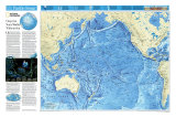
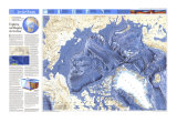
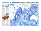
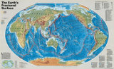
CONTINENTAL MARGINS: Submerged land between shore and ocean basin, including the continental shelf, slope, and rise. Most ocean plants and animals live in the shelf's shallow, sunlit waters.
TRENCHES: Formed when dense oceanic crust slides beneath lighter oceanic or continental crust. The Mariana Trench, Earth's deepest, plunges nearly 11 kilometers benearth the Pacific's surface.
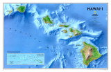
SEAMOUNTS: Active or dead underwater volcanoes rising at least a thousand meters above the seafloor. Those that penetrate the surface become islands, such as the Hawaiian chain.
ABYSSAL PLAINS: Develop in areas of high sedimentation, such as just off continental margins. These extensive, featureless regions of the ocean floor constitute Earth's flattest surfaces.
RIDGES: Underwater mountain ranges cleaved at right angles by fracture zones. The Mid-Ocean Ridge, Earth's longest mountain chain, winds 74,000 kilometers (nearly 46,000 miles) around the globe.
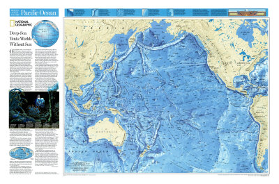
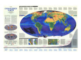
Once regarded as dark, cold, and relatively lifeless “deserts,” deep-ocean seafloors have recently been found to support small mineral-rich oases thriving with life. Unlike other known ecosystems, these self-sufficient communities of marine animals survive on energy derived not from the Sun but from Earth's interior.
Volcanic energy makes such life possible by driving a global hydrothermal circulation system at spreading centers, regions where tectonic forces slowly wrench apart crustal plates. Most seafloor spreading occurs along the spine of rifts and ridges called the Mid-Ocean Ridge. Although scientists first discovered deep-sea communities in the more active spreading centers of the Pacific Ocean, recently they found an oasis swarming with eyeless shrimp along the Mid-Atlantic Ridge.
As Earth's giant plates seprate, magma beneath the crust wells up to fill the gap, spilling onto the seafloor and creating new ocean crusts. Cooling in the frigid water, the newly formed crust develops cracks and fissures into which cold seawater seeps. How far the water descends remains unkown, but it is probably several kilometers. Tremendous heat and pressure from the underlying magma chamber cause the water to leach minerals from surrounding rocks. As convection forces the fluid back up to the seafloor, it eruupts through vents as scalding jets or diffuses over a wider area in gentle streams of warm water. As soon as the fluid strikes cold water, dissolved metals such as iron, copper, and zinc precipitate, building mineral “chimneys” as high as 50 meters and blanketing the surrounding area with metallic sediments.
Scientists estimate that the entire water content of Earth's oceans cicrulates through this rift system once every ten million years, profundly affecting sea chemisty.
As early as the mid-1960s, geologists studying seafloor spreading predicted that they might find hydrothermal vents at deep-ocean spreading centers, but they did not expect to find much life at such frigid and sunless depths. Proof that such vents exist first came in 1977 at a site 380 kilometers (236 miles) northeast of the Galapagos Islands, where at a depth of 2,500 meters (1.5525 miles) geochemists and geologists aboard the research submersible Alvin discovered not only active vents but the astonishing density of life surround them.
Illuminated by Alvin's floodlights, bunches of two-foot-long tube worms with bright red plumes swayed in the abyssal currents, clustered around limpet-encrusted lava vents whos warm streams of mineral- and bacteria-laden water registered up to ten times the ambient temperature of 2ºC. A few feet away, foot-long white clams and clumps of yellow-brown musselsfilled crevices in the lava while ghostly white crabs scrambled blindly over rocks, scavenging for food. Specially adapted to zones around the life-sustaining vents, these and other species–many previously uniown–benefit from a food concentraton as much as 500 times greater than that normally found in deep waters.
How can such abundant life exist in a reagion devoid of sunlight, the energy source plants use to produce organic compounds crucial to sustaining all other life on Earth? The answer lies in the hydro-thermal systems's chemistry.
Fluids escaping from undersea vents contain high levels of hydorogen sulfide. Although this gas is toxic to most life, certain bacteria can metabolize it. Multiplying rapidly, these bacteria form the base of vent-community food chains, such as the one at Hanging Gardens at the site called 21ºN, one of several hydrothermal sites along the East Pacific Rise. Higher organisms feast on this bacterial profusion or eat other creatures that do. Some, such as tube worms an clams, maintain symbiotic relationships with bacteria that live inside their bodies and provde them with a steady food source.
Since the first discovery along the Galapagos Rift, scientists have learned that vents differ markedly. For instance, the warm, low-lying Galapagos vents bear little resemblance to the tall chimneys found at 21ºN, called “black smokers“ for the dark metal-rich clouds they spew forth at temperatures as great as 350ºC. Vent biology varies as well, sometimes with one species dominating a given community, as at Clam Acres at 21ºN, where giant white clams cover an area the size of a football field. Across the Pacific, snails by the hundreds crowd chimney sides in the Lau Basin, near Fiji.
Because tof the dynamic geologic processes at work, vents probably last only a few decades; when a vent dies out, so do the animals dependent on it. In 1979 biologist found several species at 21ºN that matched those first observed at Galapagos–3,400 kilometers away. The presence of identical or closely related species at isolated sites suggests tha these animals survive by dispersing their larvae over great distnces to colonize new vents. However, at the Juan de Fuca Ridge, off the coast of Washngton and Oregon, the discovery of different species of inch-long clams, small tube worms, and other animals indicates that some communities may evolve separately.
Although they have explored less than one percent of the global spreading-center system, researchers expect to find deep-sea communities wherever volcanic activity fuels hydrothermal vents. That such complex biological ecosystems can exist without sunlight raises new questions about the origin of life on Earth. While most scientists believe Life began in a solar-powered environment, some argue that geothermal energy at deep-sea vents may have allowed the first primitive organisms, such as bacteria, to evolve. Determining whether life originated at vents, or adapted to them, will keep investigators debating, and diving, for decades to come.