* Lesson plan idea - have your students update the information and latest statistics concerning the Northeast coast of North American - states of Maine, New Hampshire, Vermont, Massachusetts, Connecticut, and Rhode Island in the United States and the Canadian Maritime Provinces of New Brunswick, Nova Scotia, Prince Edward Island, Newfoundland, and eastern Quebec; discuss, contrast and compare the political, economic (employment), and environmental (climate change) situations of the area. • maps
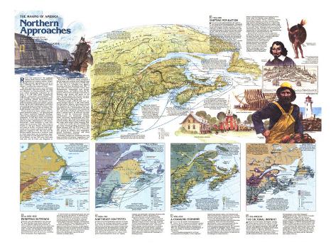
ROCKY AND FORBIDDING, the northeast coast of North America seemed most inhospitable to European settlers. inland, the thickly forested Appalachians proved no less a challenge, but the St. Lawrence River offered a way into the continent's heart.
The first explorers to arrive were Norsemen from Greenland, who built a village at L'Anse aux meadows on Newfoundland's coast 500 years before Chirstopher Columbus set sail. In 1497 John Cabot, voyaging for England, rediscovered Newfoundland. The 1500s brought French explorer Jacques Cartier and expanding fishing fleets – Portuguese, English, French, Basque, and Spanish – to exploit the teeming cod on the shallow Atlantic banks. By the early 1600s England and France were making large overlapping claims, weakly supported by fishing and fur-trading toeholds along the coast and St. Lawrence Valley.
Power seesawed as those nations strove to assert themselves. The Massachusetts Bay Colony stabilized England's holdings, while Newfoundland and Acadia remained in contention. In 1651 this colony was granted the first of several northward extensions of its claim to Acadia, culminating in a 1691 charter. Meanwhile, France continued to send colonists to the St. Lawrence Valley. The Treaty of Utrecht in 1713 gave Britain Newfoundland and parts of Acadia, yet French settlers persisted in Nova Scotia until the French and Indian War erupted in 1754. The next year the British expelled thousands of Acadians, some of whom made their way to Louisiana. Quebec's surrender in 1759 effectvely won Canada for Britain, and the 1763 treaty left France with only tiny St.-Pierre and Miquelon islands and fishing rights off Newfoundland.
Removal of the French threat prompted a British surge into northern New England. After American ndependence in 1783, Britain and the U.S. wrangled over Maine's boundary with New Brunswick until 1842, 22 years after statehood separated Maine from Massachusetts. immigration from Europe, economic forces, and politics – from the Napoleonic Wars to the rumblings of secession in Vermont - kept people and goods on the move. By mid-century the fur trade was wanding, but shipbuilding stayed strong, and lumbering and textiles were on the rise.
Canadians sought political unity and economic strength. In 1867 Nova Soctia, New Brunswick, Quebec, and Ontario formed the Dominion of Canada; Prince Edward Island joined in 1873, Newfoundland not until 1949. Railroads established new commercial ties, and ice-free Portland and Boston lured much Canadian traffic. By 1900 iron and steel began to sink the wooden-ship industry, mechaniztion was threatening marginal farms, and textile manufacturing was shifting, expecilly to the Deep South with its non-unionized labor. Fisheries and profitable pulp and paper mills helped offset economic loss.
As part of an exodus for jobs, 300,000 people – many French-speaking Americans – left Maine between 1950 and 1970. But light manufacturing and service industries spur growth in southern New Hampshire, around Burlington, Vermont, and along Maine's south coast to Portland.
Ironically, millions of vacationers now seek those qualities of isolation, ruggedness, and wilderness that made life hard in times past.
1. CA 1000-1630 - EUROPEAN OUTREACH - CODFISH, furs, and ship timbers were the real assets, but there were dreams of gold and silver. In 1583 the English took possession of Newfoundland, whose Beothuks were called “Red Indians” because they smeared themselves with ocher. Micmacs and Montagnais barted pelts to fishermen who came ashore to dry cod. Traders penetrated inland up the St. Lawrence, controlled first by Iroquoians, then Algonquians.
A French colony on Sable Island failed, and only Tadoussac marked the interior. In 1603 Pierre Du Gua de Monts obtained a monopoly on Acadian commerce, but Samuel de Champlain refocused attention inland, founding Quebec in 1608. He courted Indian traders and brought in missionaries.
In 1607 Plymouth Colony Englishmen settled the mouth of the Sagadahoc, now the Kennebec. A rigorous winter drove them away. In 1629 English proprietors divided the land between the Kennebec and Merrimack Rivers into the provinces of Maine and New Hampshire. A few fishing stations defined the faint English imprint; the area remained in Indian hands.
FATHER OF NEW FRANCE - Samuel de Champlain–artist, writer, explorer, and mapmaker who accurately charted the northeast coast from Newfoundland to Cape Cod – did more than anyone else to further France's territorial ambitions.
NEW SCOTLAND - A Scottish charter in 1621 granted Sir William Alexander much of Acadia; eight years later the Scots briefly occupied Port Royal, setting the stage for settlement of Nova Scotia.
2. 1630-1763 - NORTHEAST CONTESTED - COMMANDING the northeastern entryway to North America, the maritime region became a stetegic goal, and by the mid-1600s mainland commercial centers were sprouting. Local timber even rpovided the fastenings used by shipbuilders in Kittery and Portsmouth, which also prospered by exporting pine masts for the Royal Navy. After 1713 Scots-Irish and Puritans pushed up river valleys, where grants required proprietors to lay out “regular, compact, and defensible” townships, Between 1690 and 1760 Maine and New Hampshire saw population increase tenfold, to about 60,000.
Montreal, Quebec, and Trois-Rivieres housed half of the St. Lawrence Valley's 2,500 habitants in 1663; the Company of New France had projected 15,000. Expanding markets in the 1700s – Canada's populaton neared 70,000 in 1763 – stimulate wheat farming. Narrow lots on the St. Lawrence gave farmers access to their lifeline. Acadians diked marshlands, particularly around the Bay of Fundy, and traded with New Englanders, but by 1760, 9,000 out of 10,000 had left, banished by a British governor.
FRENCH, ENGLISH, INDIANS - Unlike the French, the English saw little advantage in befriending the Indians. King Philip's War of 1675-76 was one of a number of bloody encounters between the Abenakis and the English that delayed the opening of northern Maine.
BALANCE OF POWER - In anticipation of further conflict and to counterbalance France's Louisbourg stronghold, in 1749 Britain sent colonists to build the garrison of Halifax.
3. 1763-1850 - SHIFTING POPULATION - DISLOCATIONS and opportunities in the wake of war transformed human geography. Thousands of New Englanders quickly filled the void in Nova Scotia following the Acadian expulsion, but after 1763 many Acadians returned. Massachusetts sold colonists river tracts in Maine for less than a dollar an acre. After the Revolution numerous Loyalists left the U.S. for Canada. To accommodate them Britain created New Brunswick Province in 1784.
Planned for British settlement after conquest of New France, free lands in the Eastern Townships, such as Sherbrooke, drew Loyalists. Their objections to French law and land tenure – a feudal system of seigneural grants – led in 1791 to the divisions of Upper Canada (Ontario) and Lower Canada (Quebec and the Maritimes). By the mid-1800s population pressure and wheat failures had forced many French speakers from the seigneurial lands into the townships, sparking antagonism.
Immigrants flowed into the Northeast from Britain, Scottish Highlanders converging on Nova Scotia. After 1783 Loyalists, some with black slaves, journeyed there. Almost a million newcomers diembarked at Quebec and other Canadian ports, large numbers continuing on to the U.S. Some Irish settlers moved from New Brunswick's lumber camps to New England; others drifted into the U.S. from the St. Lawrence Valley. Although usually transient on the Newfoundland coast, Europeans cut off the Beothuk Indians from the life-sustaining sea, and with the help of the Micmacs annihilated them by 1830.
By then French Canadians from the populated south side of the St. Lawrence were joining those in the upper Saint John Valley. Canadian lumbermen encroached south, igniting the bloodless Aroostook War of 1839 (more a war of words than blows), while American foresters speculated in southwest New Brunswick. After 1830 the Kennebec Trail funneled French speakers to jobs in the Kennebec Valley. Increasingly, French Canadians manned textile mills in Maine and New Hampshire.
RIGHTS TO FISH - The treaty of 1783 guaranteed U.S. fishing rights off newfoundland A new agreement after the War of 1812 included landing privileges for Americans. Newfoundland's commerce withthe U.S. grew supplementing its trade with the Maritimes and the West Indies. French fleets continued to exploit their rights along the “French Shore.”
COAL MINING AND IRONMAKING - in the mid-1800s the U.S. was buying about two-thirds of the coal output of Nova Scotia's Picou County, where mining began in 1815. Local iron-ore deposits suppled small smelting furnaces – for example, near Annapolis Royal, Nova Scotia; Woodstock, New Brunswick; and Trois-Rivieres, Quebec.
SHIPBUILDING - With timber plentiful, North Americans could undercut European shipbuilders. Bath and the Kennebec region became the industry's northern New England nucleus. Shipbuilding was widespread in the Maritimes and concentrated around the city of Quebec.
WHICH WAY VERMONT? - Looking toward Canada but claimed by Massachusetts, New Hampshire, and New York, Vermont followed a rough path to statehood in 1791. A subsequent plot by Vermonters to seize Canada with France's help failed. In the early 1820s the Champlain Canal began reorienting trade in Vermont to New York City.
POPULATION LOSS - With Ohio country as the pull and poor farming conditions at least part of the push, thousands of New Englanders moved west in the early 1800s.
4. 1850-1950 - A CHANGING ECONOMY - ON JULY 18, 1853, the world's first internationa railway, the St. Lawrence and Atlantic, opened between Longueuil and ice-free Portland. The all-Canadian Intercolonial railroad, operational in 1876, was considered essential to confederation. it gave access to the ice-free ports of Saint John and Halifax.
French Canadians emigrated by rail from overpopulated rural Quebec to New England's factories and lumber camps, or to Montreal and other industrial cities. Lacking resources, far from markets, and hurt by freight rates, manufacturing towns in the Maritimes also lost people.
Transcontinental railroads made agriculture less competitive, while local lines encouraged specialization, such as potato growing in Maine. Railroads concentrated manufacturing and furthered lumbering, galvanized by the voracious U.S. appetite for newsprint. Maine forest declined in the early 1900s, and paper mills looked to Canadian pulpwood. Canada churned out more newsprint than any other country, its mills driven increasingly by hydroelectricity.
SEA LINKS - Roads and railroads reduced isolation within the Canadian Atlantic region, but steamer and ferry services tied this disjointed maritime area together and connected it to overseas and mainland ports, including Boston.
INVESTMENT CAPITAL - Heavy U.S. investment in the Cape Breton coalfields at the turn of the century fired local steelmaking, an by the 1920s the U.S. replaced Britain as Canada's chief source of foreign capital. Larger plants in the interior eventually depressed this industry. Americans helped finance newprint mills and fish – and food processing factories.
THE FISHING INDUSTRY - Refrigeration and rising U.S. demand for fresh fish, such as mackerel, halibut, and haddock, diminished the salt-dried cod fishery after 1900. Ports in Nova Scotia, and New Brunswick began a lucrative U.S. trade in canned and live lobsters. By the mid-20th century foreign trawlers were competing for the dwindling resources of the banks.
5. - 1950-PRESENT - THE CULTURAL IMPRINT - AFTER 400 YEARS the French, the English, and the Indians preserve distinctive cultures. In 1977 Quebec declared French its only official language but later voted against separatism. More than 80 percent of the province's 6.5 million people speak French. Quebec, eclipsed by Montreal as a commercial center, shines for French Canadians as their political captial. New Brunswick, where proud Acadians constitute more than one-third of the population, is the only bilingually administered province. Most of eastern Canada's 65,000 registered Indians live on reserves.
Of Maine's one million people, 95,000 use French, and the bilingualism issue keeps political toungues wagging. In 1980 the Passamaquoddy and Penobscot tribes won power and self-respect with an 81.5-million-dollar federal-land-claims award.
City and retired folk continue their return to the countryside. Autumn colors, winter snows, and summer breees invite vacationers to the hills of New England, while for millions Quebec holds a flavor of France, and Maine and the Maritimes offer a taste of the sea.
TRADITIONAL INDUSTRIES - Large companies manage vast tracts of commercial timberland in the Northeast. Foreign fleets depleted the fishing banks, but a 200-mile limit, enforced by the U.S. and Canada since 1977, briefly revived the industry. Large-scale shipbuilding in Maine is restricted to Bath.
ENERGY FRONTIER - The Canadian continental shelf could contain 16 billion barrels of oil and more than 85 trillion cubic feet of natural gas.
BANK IN THE BALANCE - In 1984 the International Court of Justice ended a 20-year dispute between the U.S. and Canada over Georges Bank. The decision granted the U.S. about 80 percent of the 30,000-square-mile area, but Canada won rich fishing grounds. Georges Bank could contain one billion barrels of oil and more than five trillion cubic feet of gas.