|
|
|
|
|
|
|
|
|
|
|
|
BOOKS ABOUT THE GUIANAS, GUYANA, SURINAME, FALKLAND & GALAPAGOS ISLANDS
|
|
|
|
|
|
|
|
|
|
|
|
|
|
|
|
|
|
|
 |
|
Falkland Islands, French Guiana, Guyana & Suriname Posters
for social studies classrooms, home schoolers, offices.
|
geography > South America > Falkland Islands, French Guiana, Guyana & Suriname < social studies
|
|
French Guiana, the Cooperative Republic of Guyana and the Republic of Suriname are located on the Caribbean/North Atlantic coast of South America. French Guiana is a dependency of France and was the site of the notorious penal settlement of Devil's Island.
Guyana was originally a Dutch colony, became a British possession by 1815, and granted indpendence in 1966.
The Falkland Islands (Islas Mavinas) in the southern Atlantic Ocean is an overseas territory of the United Kingdom and also claimed by Argentina.
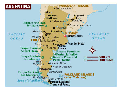
The Argentine Republic, (commonly referred to as Argentina) is located in southern South America, between the Andes Mountains in the west and the southern Atlantic Ocean in the east and south. Argentina is bordered by Paraguay and Bolivia to the north, Brazil and Uruguay on the northeast, and Chile on the south and west. Argentina also claims the Falkland (Malvinas) Islands, South Georgia and South Sandwich Islands (disputed with Great Britain) and part of Antarctica as the Argentine Antarctica (disputed with Chile).
Argentina's terrain is divided into the fertlle Pampas plains in the north, the plateau of Patagonia down to Tierra del Fuego in the south and the Andes Mountains along the western Chilean border.
The name Argentina comes from the Latin word for silver, Argentum (Ag in the periodic table).
|
|
|
|
The Falkland Island are a 776 island archipelago in the South Atlantic Ocean 300 miles east from the coast of Argentina and 584 miles north of Antarctica's Elephant Island. The islands are a self-governing Overseas Territory of the United Kingdom, but have been the subject of a claim to sovereignty by Argentina since the British invasion of 1833 and an invasion and defeat of the Argentinian forces in 1982.
|
|
|
 |
Ile Du Diabla (Devils Island) from Ile Royale in Iles Du Salut Group, French Guiana, Giclee Print
available at-
AllPosters.com
Art.com
|
|
The Falkland Island are a 776 island archipelago in the South Atlantic Ocean 300 miles east from the coast of Argentina and 584 miles north of Antarctica's Elephant Island. The islands are a self-governing Overseas Territory of the United Kingdom, but have been the subject of a claim to sovereignty by Argentina since the British invasion of 1833 and an invasion and defeat of the Argentinian forces in 1982.
|
|
 |
Ruins of Penal Settlement on Ile Royale, French Guiana, Giclee Print
available at-
AllPosters.com
Art.com
|
|
|
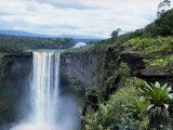
Kaieteur Falls on the Potaro River,is located in Guyana's Kaieteur National Park. The area is also claimed by Venezuela. Kaieteur Falls at 822 feet is about five times higher than Niagara Falls and about two times the height of the Victoria Falls located on the border of Zambia and Zimbabwe in Africa.
|
|
|
|
|
|
 |
Map of the Caribbean and Venezeula Print
available at-
barewalls.com
• more map posters
|
|
 |
Continent of South America Wall Poster
available at-
AllPosters.com
Art.com
• more Continents posters
|
|
 |
Satellite Map of South America Poster
available at-
AllPosters.com
Art.com
barewalls.com
• Earth from Space posters
|
|
 |
South America Political Map Art Print
available at-
AllPosters.com
Art.com
|
|
|
|
|
|
previous page | top
|
|
I have searched the web for visual, text, and manipulative curriculum support materials - teaching posters, art prints, maps, charts, calendars, books and educational toys featuring famous people, places and events - to help teachers optimize their valuable time and budget.
Browsing the subject areas at NetPosterWorks.com is a learning experience where educators can plan context rich environments while comparing prices, special discounts, framing options and shipping from educational resources.
Thank you for starting your search for inspirational, motivational, and educational posters and learning materials at NetPosterWorks.com. If you need help please contact us.
|
|
|