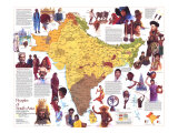
The 1997 India map features:
• A satellite map with information on the geography of India
• A map of land conditions including arable land, non-arable land, irrigated land, forest, and grassland
• Economic information including the agriculture, natural resources, and industries of the region
• A map showing population density and trends
• Six inset maps with information detailing India's history from various empires to independence
• Graphs showing gross national product, imports, and exports
• A land use graph
On the eve of the 21st century India is positioning itself as an emerging economic power–already, because of its sheer size, the fifth largest economy in the world. The country counts among its 950 million people (1997 data) a growing middle class. Well-educated, they represent a new market whose impact on the economy can already be felt in their demand for consumer goods and services. Seven years ago (1990) most of India received one television station; today there are more than 50 cable channels. Automobile sales are expected to double to nearly 500,000 by the year 2000, and wealthy Indians are clamoring to buy the $6,000 Maruti, a Japanese-style minicar.
Despite this new affluence, India still suffers one of the world's lowest per capita incomes, with illiteracy, unemployment, and overcrowded housing. The task ahead is for India to bring its people–in all their ethnic, religious, and political diversity–to the table of economic success.
INDIA FROM SPACE
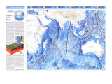
A satellite mosaic reveals a subcontinent still in the making. Riding a tectonic plate, the giant island that became India rammed into the Asian mainland 50 million years ago. The land gradually buckled and heaved the Himalaya range upward into elevations of perpetual icy barrenness. From their foothills India unfurls as river-threaded and crop-rich plains. The Great Indian, or Thar, Desert in the west, irrigation from Indus River tributaries supports millet cultivation. The Deccan Plateau, flanked by the low mountains of the Eastern and Western Ghats, ends in the Nilgiri Hills, just north of Anai Mudi, at 8,841 feet the highest peak south of the Himalaya.
With the world's highest mountains to the north and Indian Ocean washing all other sides, the subcontinent is locked into the immense weather system of monsoon winds. They bring necessary rains that sometimes swell into devastating floods.
Changing Faces of India: Empires to Independence -
The Roots of Indian Culture
The Indus Valley, or Harappan, civiliation emerged about 2500 B.C. as a sophisticated urban society with a system of writing and measurements. A thousand years later, Aryans brought from the north a culture and rituals that later became a basis of Hinduism. About 320 B.C. the Maurya family took power, influenced by the statecraft of Alexander the Great. Their empire peaked between 273 and 232 B.C. under Ashoka, who made Buddhism the state religion. Pillars and boulders inscribed with his royal edits still stand.
Gupta Empire
The classcal period of Hindu art, literature, and science (A.D. 320 to 647) took root during the Gupta dynasty, reaching its peak during the reign of Chandragupta II (A.D. 375 to 415). Building on the campaigns of his father, Samudragupta, he extended his influence farther southward. The Gupta rulers promoted Brahamanism, an early form of Hinduism, throughout their realm. Though the last strong Gupta king, Skandagupta, held off invading Huns in the fifth century, the empire soon collapsed.
Sultanate of Delhi
One invading force after another plagued and plundered India from the 5th to the 13th centuries, an era of political turmoil and shifting boundaries. As Islam spread, a Muslim sultanate was established in Delhi in 1206. It soon expanded south, absorbing many Hindu kingdoms, including the domain of the powerful Yadavas dynasty. In 1526 Babur, a Muslim chieftain from Central Asia, defeated the last Delhi sultan and established the Mogul Empire that would shaped the subcontinent for the next 200 years.
Mogul Empire
In the 1500s Europeans began vying with Arab merchants for India's sea routes. Europeans extablished ports like Goa and Pondicherry and made trade agreements with powerful Mogul emperors such as Akbar. Ruling from 1556 to 1605, he set a tone of religious tolerance; his son and grandson presided over an era glorious in art and architecture. Great-grandson Aurangzeb expanded the empire, which held as many as 150 million subjects at its height before ebbing after his death in 1707.
British Expansion
Taking advantage of the lack of central power in the 1700s, the British East India company began taking over much of the subcontinent, manipulating conflicts between local rulers and imposing taxes. Its strategy is illustrated by the 1799 partition of the state of Mysore. The company gave some territory to princely states, gaining political influence in exchange for protection, and claimed the rest of the state for itself. In 1857 sepoys, or Indian soldiers, rebelled against social and religious indignities. Civil discontent spread the Indian Revolt, suppressed in 1859.
Road to Independence
Britain seized control of the East India company's holdings in 1858. Indians became increasingly critical of British rule and its inequality. After World War I, political activist Mohandas Gandhi sent out a cry for independence through nonviolent disobedience, and millions answered. In 1940 the Muslim League, afraid of a Hindu-run government, called for an independent Muslim state. After massive riots between Muslims and Hindus in 1946-47, Indian and British leaders agreed to partition the country; in August 1947 India and Pakistan gained independence. In 1971 Muslims in East Pakistan broke away to form Bangladesh.
POPULATION QUANDARIES
By the turn of the century India will be home to more than a billion people. By mid-century it will surpass China as the world's most populous country. Although three-fourths of the nation's people–most of modest means, many impoverished–live in rural areas, urban populations are soaring in cities like Mumbai (Bombay), where a quarter of a million farmworkers arrive yearly in search of employment.
Reducing India's annual growth rate of nearly 2 percent ranks among the government's most urgent priorities, but significant decrease are at best decades away. Until then the country must try to keep up with the housing, health, and education needs of 18 million more people every year.