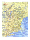
NEW ENGLAND, more so than any other region, holds the key to making of America. To its colonists can be traced quintessential American qualities: regard for religion, respect for education, relish for work, and restlessness of spirit. New England's colonial heritage helped lay the foundations of American democracy, and in New England's founding industrialist's can be seen the entrepreneurship that figured strongly in making the United States preeminent among manufacturing nations.
Not until early in the 1600s did European powers establish toeholds to validate long-standing charter claims. New England's population, although tiny, soon exceeded that of New France and New Netherlands combined. A seed of permanent English colonization germinated at Plymouth in 1620; a decade later a convoy of English Puritans landed at Salem. By the mid-1600s more than 15,000 religious exiles had stepped ashore in the Great Migration. In time and with the influence of newcomers – Scotch-Irish Presbyterians, Quakers, and others – New Englanders shed their Puritan mantle, becoming indpendent-spirited Yankees.
Britain's triumph over France in 1763 caused great shifts of peoples, and the war for American independence brought further upheavals. Former colonies settled boundary disputes, and in 1791 the independent republic of Vermont joined the Union as the 14th state. Footloose Yankees continued streaming west and north, seeking fertile lands beyond the confines of the region.
As a new century turned, so mill wheels began turning in the Northeast. New England had the ingredients for industrial success: abundant water power and capital, a trainable labor force, and a wealth of inventors and entrepreneurs.
European and Canadian immigrants provided muscle for strong growth through the late 1800s. After World War I, textiles production fell while that of the South rose, and shoe manufacturers moved to the Midwest. In the 1930s the Great Depression made bad times worse. Between 1919 and 1939 almost 400,000 workers lost their jobs–eight times the rate of decline in the rest of the nation.
World War II fostered an electronics boom spearheaded by New England. By 1960, when John F. Kennedy's election as President signaled the dying embers of tension between Irish Catholics and Yankee Protestants, New England brainpower was sparking a high-tech wildfire. Today's vitality draws from a legacy of educational excellence reaching back to the Puritan era.
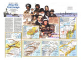
1 - To 1626 - INDIANS AND OUTPOSTS - EXPLORERS, FISHERMEN, AND FUR TRADERS in the 1500s were the first Europeans to encounter Indians in the Northeast. In the early 1600s explorer Samuel de Champlain's reports of hostile tribes in large villages along the southern coast prompted France to turn to the St. Lawrence region. In 1606 the King of England granted the Virginia Company of Plymouth extensive colonization rights, but the subsequent failure of Sir John Popham's colony delayed settlement attempts.
In 1614 Capt. John Smith charted the coast and on returning home whipped up interest in “New” England. Although Smith judged the coast north of the Penobscot River “a Countrey rather to affright than delight,” he promoted the Massachusetts Bay area as “the Paradice of all those parts.” In 1620, when the Pilgrims chose an Indian-village site for a colony at Plymouth, coastal tribes posed virtually no threat. An epidemic, possibly chicken pox introduced by European fishermen, had ravaged Indians between Penobscot Bay and Cape Cod.
Inland tribes were disrupted by the competition for furs betweeen the French an their Indian allies north of the St. Lawrence Valley and the Dutch, who courted tribes along the Hudson River. The Iroquoian Mohawks, who sought control of trade at the Dutch post of Fort Orange, drove the Algonquian Mohicans east of the Hudson.
COUNCIL FOR NEW ENGLAND - In 1620 King James I patented a “Council ... for the planting, ruling, ordering and governing of New England in America.” This Council for New England received lands stretching from the Atlantic to the Pacific, and in 1622 it granted Sir Ferdinando Gorges and Captain John Mason a substantial coastal area.
NATIVE NEW ENGLANDERS - Before the spread of European diseases, New England was the home of 70,000 to 100,000 Indians. Tribes south of the Kennebec River grew maize, beans, squash and tobacco, supplementd by hunting and gathering. The fewer northern Indians lived mainly by hunting, fishing, and collecting shellfish.
2. 1626-1760 - PURITAN COMMONWEALTH - UNLIKE OTHER COLONIAL ventures, the Massachusetts Bay Company was governed not by London officials but by the Puritans themselves. Boston emerged early as the center of a commonwealth reaching beyond New England. Pressure on coastal land, the pull of the fur-rich interior, and religious intolerance – Puritan leaders brooked no dissent – fueled town building abd splinter colonies.
In the 1630s Puritan outcast Roger Williams established Providence (RI). The Reverend John Wheelwright fled to New Hampshire to found a settlement, one of four Massachusetts had annexed by 1643. New Hampshire became a royal provice in 1580, but Massachusetts continued to rule Maine, exploiting its fish and lumber. The Puritan colony of New Haven joined Connecticut in 1665. As New England larders, Connecticut provided mostly grains while Rhode Island supplied livestock.
BIG LEGACY OF SMALL TOWNS - The Puritans sent out groups of families to build new towns. Massachusetts' system of local government – a cornerstone of American democracy – hinged on town meetings. Townsfolk voted on issues, and selectmen, the elected officils, carried out the democratic decisions.
BOUNDARY PROBLEMS - After 1629 land-hungry Massachusetts contested the southern boundary of the Council for New England's grant of New Hampshire to John Mason, and a line was not drawn until 1741. New Hampshire and New York continued to wrangle over the region that would become Vermont.
3. 1760-1800 - GREATER NEW ENGLAND - AFTER BRITAIN and France made peae in 1763, emigration to Nova Scotia quickened. New England had become overcrowded, and the British expulsion of French Acadians from Nova Scotia had made farmlands available. Yankees soon formed more than two-thirds of Nova Scotia's 18,000 people. Yankee pioneers also ventured up the Maine coast and into the upper Connecticut Valley. New Hampshire encouraged settlement in Green Mountain valleys, also claimed by New York. A Connecticut company planted a colony in the heart of Pennsylvania, around Wilkes-Barre, and in 1774 Connecticut annexed this area.
After the close of the Revolution in 1783, tens of thousands of British Loyalists left for Lower Canada. The shortage of arable land in New England, heavy taxes, and sheer wanderlust stimulated even greater Yankee migration. Eastern Massachusetts lost settlers to Maine, whose pristine wilderness also drew families from New Hampshire. With the Canadian government encouraging immigation, farmers – along with merchants, millers, and innkeepers – surged north across the international boundary in the 1790s.
To the west, the Mohawk Valley channeled pioneers to Utica, New York; from there many proceeded along the Genesee Road to the Finger Lakes country. Although speculators had locked up hugh tracts in western New York and the Ohio country, these touted frontiers enticed hordes. Ater investors acquired prime territory around the Genesee River, Massachusetts and Connecticut succumbed to “Genesee fever,” which spread when blocks were offered to “the industrious yeomanry of Vermont and New Hampshire.”
By 1800 the restless Yankees had impressed their cultural and commercial stamp upon a region far greater than New England, whose core cities were then crossing into the industrial age.
BRITISH DEFEAT IN THE INTERIOR - Britian's attempt to quell the Revolution that began in Lexington and Concord on April 19, 1775, included a naval blockade of the coast and a two-pronged military campaign from Montreal ... to isolate New England. Approaching via the St. Lawrence, Lt. Col. Barry St. Leger would seize Fort Stanwix and march east to join Gen. John Burgoyne, who planned to take Albany and win control of the upper Hudson Valley. But on August 23 Maj. Gen. Benedict Arnold drove St. Leger from Fort Stanwix. Arnold also helped Maj. Gen. Horation Gates force Burgoyne's pivotal surrender at Saratoga on October 17, 1777.
TRADING NETWORKS - By the late 1760s New England was exporting pig iron to England and buying British fabrics and other manufactured goods. New England ships carried pine masts, naval stores, and dried fish ot Europe. Trade with the West Indies centered upon slaves. molasses, and rum distilled in Boston and other seaports.
RESOLVING TERRITORIAL DISPUTES - After the Revolution the conflicting claims of former colonies were unscrambled. Connecticut gave up its claim to a chunk of Pennsylvania, although a Connecticut land company later proposed subdividing land just west of Pannsylvania. In 1786 Massachusetts relinquished its ocean-to-ocean charter. New Hampshire and New York withdrew their claims to Vermont in 1782 and 1790 respectively.
4. 1800-1860 INDUSTRIAL HIVE - THOMAS JEFFERSON had hoped in 1785 that Europe would continue to dominate the “general operations of manufacture,” but by 1816 he acknowledged that “We must now place the manufacturer by the side of the agriculturalist.”
Among those who laid the foundations of New England's cotton-textile industry were Samuel Slater, an Englishman who duplicated the Arkwright milling system in Pawtucket, Rhode Island, in 1790, and Eli Whitney, a New Englander who invented* the cotton gin in 1793. In 1814 an innovative factory at Waltham, Massachusetts, was the first to concentrate cotton spinning and weaving in one place. Boston capitalists financed mammoth mill complexes at major water-power sites morth and west of the city, and by 1860 New England's mills were clattering out two-thirds of the nation's cotton goods.
Textile milling – both cotton and wool – was widespread, but other industries tended to cluster, often because skilled craftsmen had set up shop in certain areas. Welshman John Dagyr introduced shoemaking techniques at Lynn, Massachusetts. Waterbury's brass works grew out of handcrafting of buttons. and Eli Whitney's New Haven musket factory helped stimulate machinery production in southwestern Connecticut. Providence's jewelry industry owed much to Nehemiah Dodge, who perfected a method of gold-plating.
WHALING-A NEW ENGLAND MONOPOLY - By 1820 Nantucket had a fleet of more than 70 whalers, but New Bedford soon became the chief whaling port. The vessels sailed to the polar seas, the Pacific, and the Caribbean. Whales yielded lamp oil and baleen, a springy substance that was the basis of skirt hoops and corset stays.
BY LAND AND BY SEA - By the 1840s railroads were emptying the holds of canalboats. In the race to extend rails into the heartland, Boston lost out to more accessible New York, Philadelphia, and Baltimore. Boston Harbor was a major portal, and between 1820 and 1855 some 300,000 immigrants, more than half of them Irish, alighted on its piers.
5. 1860-1945 - IMMIGRANTS AND INDUSTRIES - A WRETCHED SEA VOYAGE in steerage was the way out for most Irish emigrants, whose exodus had begun in the mid-1840s when a potato blight spread famine across Ireland. Many landed in Canada's Maritime Provinces and walked to New England, taking jobs as mill workers and farm and construction laborers. Many others disembarked in Boston. In 1885 the election of Boston's first Irish mayor heightened rising tension between the Yankee Protestant minority – the old-stock Brahmins who jealously guarded their economic power – and the poor but ambitious Irish Catholic majority.
In the 1880s French Canadians, unable to make ends meet farming in Quebec, began replacing Irish workers in cotton and pulp and paper mills in Maine and New Hampshire. The French Canadians crowded into neighborhoods called “Frenchvilles” in towns such as Biddeford, Lewiston, and Berlin. By World War I they formed New England's second largest language group.
In the 1890s a new wave from Europe swept in southern Italian and Sicilian peasants escaping poverty that stemmed from a feudal farming system. Italians were drawn to shoe factories in eastern Massachusetts and textile mills in Rhode Island. Portuguese, Swedes, Greeks, Syrians, Armenians, and Poles also arrived before the 1920s, when the industrial boom ended and federal legislation curbed immigration.
PULPWOOD AND PAPER - After the Civil War wood pulp became the preferred paper-making material, and northern New England, with thick forests, had a natural advantage. With its huge pulp and paper mills Maine rolled out more newsprint than any other state in the nation until the 1920s. Thereafter new England began specialiing in high-qualtiy paper.
TWO NEW ENGLANDS - “The only place that's growin' 's the cemetery!” wrote Rollin Lynde Hartt about one northern New England town in the late 1800s. Competition from grain-belt states, as well as the lure of the West and southern New England's mill towns, caused the abandonment of hill-country farms. But by the 1930s specialty farming and a new industry – recreation – were invigorating the northern economy.
6. 1945-PRESENT - A NEW VITALITY - BETWEEN 1947 and 1985 the number of New Englanders employed in services – for example, education, health care, banking, insurance, and data processing – rose from 370,000 to 1.5 million. Services now provide two out of three new jobs.
Top-notch schools and centers of highter learning have eased the transformation from an economy based on goods such as cotton textiles, lured South by cheap labor, to one based on services and high tech. Some 750,000 students in more than 260 colleges and universities represent a brain bank of unmatched potential.
By 1949 when the Soviet Union had detonated its first atomic bomb, Cambridge, Massachusetts – home to Harvard University and the Massachusetts Institute of Technology – was the electronics hub of the U.S. By the 1960s, when the space race was speeding up, Route 128 corridor fringing Boston's western suburbs bristled with space and missile firms. In the late 1970s high-tech industries, ranging from electronics to computer-programming companies, surged north ward from America's Technology Highway, as Route 128 is known, into southern New Hampshire's Golden Triangle, with points at Manchester, Nashua, and Salem.
Just as New England thrives on the wits of its people, so does it profit from the beauty of its land. Tourism has injected new life into the backcountry, where mountain, forest, lake, or seashore beckon.
KEEPING VERMONT GREEN - The Green Mountain State has managed to fend off the worst of 20th-century American life. Billboards are banned, and there are strict zoning ordinances, many designations for wilderness lands and stringent antipollution laws.
FLOUNDERING FISHERIES - After 1950 the availability of frozen fish, which reduced local demand for fresh fish, and increasing mechanization put many New England fishermen out of work. Nevertheless, Gloucester, New Bedford, and other fisheries still take in a tenth of the nation's catch, mostly flounder, haddock, and lobster.
COASTAL PLAYGROUND - Maine's rugged coast attracts vacationers from all over the U.S., but mainly from Boston and other northeastern cities. For swimmers, places such as Old Orchard Beach are popular, while for those intent on soaking up the ambience of historic towns, there are York, Camden, Boothbay Harbor, and Wiscasset. Penobscot and other bays are popular for sailing.