|
|
Rivers of Europe Posters, Prints, Photographs, and Maps
for social studies, science educators and home schoolers.
|
geography > landforms > rivers > EUROPEAN RIVERS < social studies
|
|
 Rivers are narrow bodies of fresh water that follow a path and erode away the land they flow over creating land forms such as deltas, canyons and valleys. Rivers were the first great pathways of humanity and we can study civilizations by exploring waterways today. Rivers are narrow bodies of fresh water that follow a path and erode away the land they flow over creating land forms such as deltas, canyons and valleys. Rivers were the first great pathways of humanity and we can study civilizations by exploring waterways today.
|
|
|
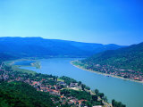
The Danube, the longest river in the European Union and Europe's second longest river after the Volga, is the joining together of two smaller rivers rising in the Black Forest of Germany.
The Danube plays an important role in European history as it flows eastward through the major European cities of Vienna, Budapest, and Belgrade and the countries of Germany, Austria, Slovakia, Hungary, Croatia, Serbia, Montenegro, Bulgaria, emptying into the Black Sea at the border of Romania and Ukraine.
The Proto-Indo European root “danu” means river or stream.
In 1866 composer Johann Strauss II composed the Blue Danube waltz, which has become an unofficial national anthem for Austria.
|
|
|
|
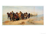
The Don River flows from near Moscow to the Sea of Azov, 1200 miles to the south. In antiquity, the river was viewed as the border between Europe and Asia by some ancient Greek geographers.
Nobel Laureate Mikhail Aleksandrovich Sholokhov features the Don River in his works.
|
|
|
|
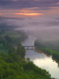
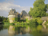
The Dordogne and its tributaries in southwestern France are home to the cave systems that contain wonderous painting by prehistoric hominids. Sites such as Lascaux have been designated World Heritage sites by UNESCO.
The Dordogne which flows from Massif Central (the highest mountain in central France) to the shared Garonne estuary on the Atlantic Coast, has what is known as a tidal bore, where the incoming tide forms a wave(s) against the current.
|
|
|
|
The Dnieper River flows from Russia, through Belarus and Ukraine, to the Black Sea.
It is an important navigable waterway with a history going back to the Amber Road trade route; it is also a source of hydroelectric power.
The Dnieper flows through Kiev.
|
|
|
|
The Elbe rises in the Czech Republic, crosses Germany and empties into the North Sea.
Notable cities on the Elbe include Dresden, Wittenberg, and Hamburg.
|
|
|
|
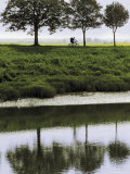
The Loire River is the longest river in France. It rises in south-east France and flows west to the Atlantic Bay of Biscay.
The Loire River Valley is called the “Garden of France” with noble chateaux and grape vineyards lining the banks of the river.
Cities along the Loire include Tours, Orleans, and Nantes.
|
|
|
|
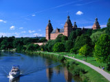
The Main River in Germany is one of the largest tributaries of the Rhine, and an important part of the transportation route link from the North Sea to the Black Sea.
|
|
|
|
The Marne, which is a tributary of the Seine, was the site of two World War I battles.
|
|
|
|
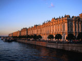
The Neva River in northwestern Russia flows from Lake Ladoga through the western part of Leningrad Oblast to the Neva Bay of the Gulf of Finland.
The city of Saint Petersburg in on the Neva River, to the south of the Karelian Isthmus.
|
|
|
|
The Oder River of central Europe rises in the Czech Republic, flows through central Poland forming a border with Germany and Poland, finally flowing into the Gulf of Pomerania of the Baltic Sea.
|
|
|
|
The Po River, Il grande fiume or ‘great river’, is the longest river in Italy, fed by 141 tributaries draining a catchment basin of 27,000 square miles that includes the cities of Turin and Milan.
The Po flows east to west creating the Val Padana, a plain that stretches across northern Italy from the French border and Alps on the west to the Adriatic Sea on the east, just south of Venice.
|
|
|
|
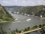
The Rhine River flows northward from the Alps in eastern Switzerland, forming borders with Liechtenstein and then Austria, through Lake Constance, Germany, France and the Netherlands, emptying into the North Sea at the Rhine-Meuse Delta.
Large cities on the Rhine include Basel, Bonn, Cologne, Dusseldorf, Rotterdam, Strasbourg, Utrecht.
Among people associated with the Rhine River are mystic Hildegard von Bingen, composer Richard Wagner and Das Rheingold opera inspired by the Nibelungenlied legends, and Heinrich Heine's Die Lore-Ley poem about Lorelei myth.
American poet Walt Whitman called the Rhine “The most beautiful river in the world.”
|
|
|
|
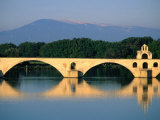
The Rhone River, one of the major rivers of Europe, originates at the Rhone Glacier in Switzerland and flows through Lake Geneva and southeastern France to the Mediterranean. The Rhone follows a north-south cleft separating the Alps from the Massif Central.
The major French city of Lyon is on the Rhone.
At Arles, the river divides into two branches, the Great Rhone (French: Grand Rhône) and the Little Rhone (Petit Rhône). The resulting delta constitutes the Camargue region.
|
|
|
|
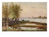
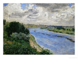
The River Seine derives its name the Gaul Sicauna, which means sacred river.
The Seine flows through Paris, and has been inspiration for many artists, see Alfred Sisley.
• France posters
|
|
|
|
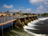
The River Shannon is the longest river in Ireland and a major physical barrier between east and west Ireland.
The geographer Ptolemy was first to map the Shannon c. 130 AD.
FYI - a “weir” is a type of dam that usually is a barrier that causes water to pool behind the structure and flow over the top.
|
|
|
|
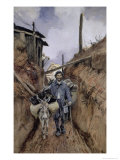
The Somme River, in northern France and only 245 km long, flows from Fonsommes to the Bay of the Somme in the English Channel.
Its location made the Somme the site of several historic events.
In 1066 William the Conquerer assembled his Invasion Fleet at the mouth of the Somme.
In 1415 armies crossed the Somme before the Battle of Agincourt (see William Shakespeare's Henry V).
The Battle of the Somme (July-November 1916) was one of the largest battles of the First World War where the forces involved (British and French against the Germans), had suffered more than 1 million casualties, making it one of the bloodiest military operations ever recorded. The Second Battle of the Somme in 1918 was the beginning of the end for the Germans.
FYI ~ the name Somme is Celtic and means tranquil.
|
|
|
|
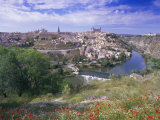
The Tagus, the longest river on the Iberian Peninsula flows from the southwestern end of the Iberian Mountain System through Spain, then forms a small part of the border between Spain and Portugal, before crossing Portugal and flowing into the Atlantic Ocean at Lisbon.
The lower part of the Tagus follows a fault line responsible for many earthquakes with major events in 1309, 1531, and 1755.
FYI - the longest bridge in Europe is the Vasco de Gama bridge near Lisbon.
|
|
|
|
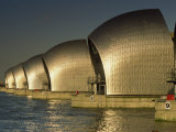
The River Thames, which has supported human activity for milleninia, rises in the west-central Cotswold Hills of Gloucstershire and flows through southern England emptying to the North Sea at the Thames Estuary, the world's second largest tidal movement.
Because the Thames is a tidal river, London is under the threat of severe flooding when the conditions of weather and high tide push water up the Thames from the sea. On December 7, 1663 Samuel Pepys wrote in his diary, 'There was last night the greatest tide that was ever was remembered in England to have been in this River, all Whitehall having been drowned.'
The word Thames is from the Middle English “Temese” and derived from the Celtic name for the river; scholars link the word to Sanskrit and Irish words that means “dark”.
The Thames Tunnel, engineered by Marc Brunel, was the world's first underwater tunnel.
|
|
|
|
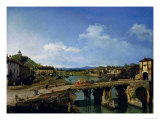
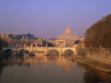
The Tiber River is the third-longest river in Italy. It rises in the Apennine mountains and flows to the Tyrrhenian Sea off the west coast of Italy.
According to legend, the city of Rome was founded in 753 BC on the banks of the Tiber.
|
|
|
|
The Ural River, which rises on the southeastern side of Ural Mountains, flows through Russia and Kazakhstan into the Caspian Sea.
Due to the course of the Ural River, it is arguably a geographic boundary between Asia and Europe.
The vast wetlands delta of the Ural River is called a digitate, a tree like shape that occurs when a slow moving river enters a calm sea.
FYI ~ Catherine the Great decreed the name of the river Ural in 1775; it's original name was Yaik, Ptolemy called it Jajykon on a map from the 2nd century.
|
|
|
|
The Vistula River is the longest river in Poland, rising in the Carpathian Mountains and flowing north into the Gdansk Bay on the Baltic Sea. Scientists predict it is likely most of the Vistula Delta region, which is below sea level, will be flooded due to the sea level rise caused by climate change by 2100.
The Vistula was part the Amber Road, an ancient trade route through Europe and Asia that connected northern Africa with the Baltic Sea.
Kraków and Warsaw are among the important Polish cities on the banks of the Vistula.
|
|
|
|
The Volga is the largest river in Europe in terms of length, discharge, and watershed, is considered the national river of Russia. It rises between Moscow and St. Petersburg, and flowing eastward carves a wide half circle through central Russia before bending toward the Don (“the big bend” where Volgograd, formerly Stalingrad, is located) and on to the Caspian Sea.
The fertile Volga river valley is an important farming area, producing large quantities of wheat, and also has many rich mineral deposits.
The Song of the Volga Boatmen is a traditional Russian folk song sung by the burlaks, or barge haulers, who needed to work in rhythm to pull the loaded barges along the river.
The wetlands formed where the Volga flows into the Caspian Sea is the fishing grounds for beluga sturgeon, the source of beluga caviar . .
|
|
|
|
Hydrosphere: Water Environments
Poster Text: Water is stored in the hydroshpeher in areas called resovoirs. These reservoirs include the atmosphere, oceans, lakes, rivers, soils, glaciers, snowfields, and groundwater. Water is essential for life, and many of these reservoirs provide water environments for living organisms. Wetlands, coral reefs and open oceans are examples of biomes in which water plays a major role. The tropical rainforest biome, which supports the majority of the Earth's biodiversity, dependes on rainfall to sustain its abundant life.
There are many types of watery environments. These range from freshwater ponds to salty seas, whcih contain three times the salt concentration of the ocean.
The largest water environemnt on Earth is the ocean. Oceans cover 71% of the Earth's surface and are responsible for producing about half of the world's biomass (the weight of all plants, animals, fungi, and microbes in the biosphere). Most organisms in the oceans live at the sunlit ocean surface. Below 25 meters there is little light to support photosynthesis for plants, which are the building blocks for the rest of the food chain.
Wetland habitats support an immense diveristy of life, from tiny microscopic organisms to reptiles, to large mammals. By definition, wetlands are lands on which water covers the soil or is present either at or near the surface of the soil. In coastal wetlands and estuaries, the salt water and tides combine to create an environment in which only salt-tolerant species (halophytes) can survive. Inland wetlands include food plants along rivers and streams. Marshes and wet meadows are dominated by grasses and other non-woody plants or shrubs, while swamps are dominated by trees.
• more ecosphere posters
|
|
|
|
previous page | top
|
|
I have searched the web for visual, text, and manipulative curriculum support materials - teaching posters, art prints, maps, charts, calendars, books and educational toys featuring famous people, places and events - to help teachers optimize their valuable time and budget.
Browsing the subject areas at NetPosterWorks.com is a learning experience where educators can plan context rich environments while comparing prices, special discounts, framing options and shipping from educational resources.
Thank you for starting your search for inspirational, motivational, and educational posters and learning materials at NetPosterWorks.com. If you need help please contact us.
|
|
|